SWCP: St Ives - Pendeen Wild Camp
I did another training hike on the SWCP. I did the first one a few weeks ago and had to bail out at 10k due legs seizing up due to poor hydration strategy. Never had so bad cramps on legs before.
My plan was to set out from St Ives and see how far I can get, but the plan was to get to St Just. I hadn't walked from St Ives to Zennor as it's been described as one of the hardest sections on the path, so I was expecting the worse. Missus dropped me off to top of St Ives in the morning and headed to Co-op for supplies. I didn't bring a cook kit as many people walk the path without carrying cook kit and just eat in local cafes and pubs so I thought I test this.
St Ives was nice and quiet at 9am on Thursday morning outside peak season apart from local yappy lapdogs. I rarely go to St Ives as it's usually full of tourists and parking is a nightmare.

I walked around St Ives, The Island (poorly way marked path) and Porthmeor Beach following a paved walkway, which then turned into a dirt path and eventually a grazed hill.

After that the path was slightly muddy and had big rocks which can be used as stepping stones. I thought this can't be the hard bit. The trail was relatively dry despite having a proper storm couple of days earlier. I can understand that walking on wet rocks is not the nicest, which explains the muddy path next to them which most people seem to prefer. The stones are also used in areas where the streams tend to flow on the path. The stone section ended and the path turned into a regular narrow dirt path. There were couple of steep climbs and rocky paths, but I was still waiting for the 'hard' section. Lots of German tourists on the path.
The path eventually turned to a regular SWCP, headlands and ups and downs.

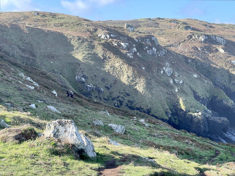
It was easier than expected based on what people say. Yes it's craggy, but not more than any other section that can be found on the path. Approach to Zennor got more rocky and harder. I was trailing a German family where the dad in his full hiking kit and kids were zooming ahead while the mother was looking flustered, yelling at the rest of the family and cursing in German.
Remnants of big wild fire from last summer.

I walked into Zennor which has a nice pub Tinners Arms and a Moomaids Cafe. Selected the cafe and asked about the food, but they had run out of all the savoury foods, so I just had a snack and was off. I didn't go to the pub, as I can't eat big meals when I walk. Despite this, the legs felt heavy and I was contemplating during the first ascent from Zennor about turning back. It didn't help that the path has really rocky sections on either side of Zennor, which makes the walking slow.
I decided push on and after a while felt better and the path improved. I got a second wind and I had a few potential campsites in mind, which I had scouted on the previous hike. Whenever I walk on the SWCP, I mark potential wild camp spots on my maps.
Gurnard's head in the distance. The path doesn't go around this headland, but passes it on the mainland side. This is also a good bail out point, as there's a gastro pub close to the path, incidentally named Gurnard's Head.

I reached my first previously scouted campsite. I took a break onsite and was checking out how I'd set up the tent. While I was pondering whether to continue to the next scouted site at least an hour away, a drizzle started. It wasn't suppose to rain all day, but that's coastal weather for you, so I took it as a sign and started to set up camp. I checked the wind direction and aligned tent to more sheltered side. Turned out there was only thin topsoil before the hitting solid rock. I tried to use the big rock, little rock method but there wasn't enough big rocks around. I cursed in my mind that I'd get wet while packing the tent if I needed to head out to the next campsite. I decided to walk around the site with a peg and shoving it into the ground to test if I could find a spot with enough topsoil for the pegs. I found that on the other side of the side that was the case and luckily the drizzly cloud passed. I set up the tent and waited while having a bite to eat. OS Maps shows this area to be access land, so I wasn't expecting to be moved on, but I was cautious as there was a paddock with cows on it on the other side of the hedge. I thought that if I was asked to move, at least I didn't have to pack up everything, just the tent. The sun started to set, so I proceeded to get everything ready for the night.

The winds weren't big, but occasional gusts were strong enough to make sure that light items would need to weighed down with something. I pegged the Pro2 down as much as I could, but because some of the corners were a bit higher, there was a bit of a gap between the fly and the ground. I didn't think that'd be an issue and I thought there'd be less condensation inside with the top vents open.
The night turned out to be one of the worst in a tent in a while (not that I've had that many, but still). Despite having completely still night at times, there were also big gusts of wind which would shake the tent and make the panels rattle loud making it hard to fall asleep. I thought I had ear plugs in my toiletry kit, but no luck. On top of that, the moon came out and was like someone had left the night light on. I dug out my buff and put that over my ears and eyes. Despite breeze occasionally moving my hair inside the tent. It almost felt like the campsite was haunted. I thought I'll charge my watch and my phone, but my Nitecore 20000 was stuck on charging mode and wouldn't discharge anything (apparently it's a thing). I had about 40% battery left on my phone. I thought I listen to a podcast as I thought it'd use the least amount of battery compared to video or reading which use the screen. I listened the Trail Show episodes from 2016 where they slagged off the Te Araroa which they were thru-hiking at the time.
It was a rough night. I barely got any deep sleep due to being woken up by the tent rattling ghosts of dead miners. I woke up 6.44am which was about 45min before the sunrise. I decided to pack and get going. 15min past the sunrise I was on the trail. Not the fastest break, I know.
I dropped down to Porthmeor Cove and started climbing up. Whereas I didn't feel any soreness from the longest & hardest day I'd done in ages, I definitely lagged the pep in my step. I decided to take it easy, keep moving at slow pace and small steps. The path didn't get any easier.

I passed the Bosigran Castle and while I was descending I saw some strange movement on the Commando Ridge. I thought it was an animal chasing another. The I realised that it was a black & white Collie running up the hill while the owner was scrambling up the steep face on almost all fours which made it look like a another four-legged animal chasing the dog. We reached the ridge around the same time and the woman, a local artist and her dog, Aria were just around taking photos from unusual angles. We worked together for a little bit and then she stopped to do some drawing.
I passed my previous training hike's bail out point, which was nice. Despite heavy legs, I kept trotting on. My hydration strategy was working. I had to drink a lot more than I had thought and had to take in more electrolytes. I looked at the OS Maps. Rest of the trail looked like it'd be mostly flat and so it was. The path turned into a SWCP highway, like I call them. Path that suddenly changes into a wide, flat, often grassy and makes walking quick and easy. I saw Pendeen lighthouse in the distance.

I got to amazing Portheras Cove. It was quite a sight coming from this side. After the cove, a long, steady ascent lead me to Pendeen lighthouse.

The ascent had properly burnt my legs. My phone had 19% battery left. I could've gone on, but I didn't want to be on the trail without a phone in case something happens. There's no signal all long the SWCP, but Penwith peninsula is pretty well covered. I also wanted to have access to OS Maps to find a route out of path if needed. I would've probably taken me about 1-2h from Pendeen to St Just. I remembered that there was a bus stop in Boscaswell. So I walked the 2k on road out of Pendeen lighthouse to the bus stop and took a bus back to Penzance.
Conclusion
It was a good outing. Hard going on the north Cornish coast is a good practice for any hike. Soon I've walked all of the path on Penwith peninsula.
The Good:
I've now a few outings with Zpacks Arc Ultra T and it seems work for me. I've made a few mods and will make a couple more, but I never felt that I had to take the pack off during breaks for a relief. It did help that the all in weight of the pack excl. food & drink was under 6kg.
EE Revelation kept me nice and toasty, as it should because it's rated to 0c, but it's a nice and comfy quilt.
Since the pack is very water resistant, I use pods and dry bags to organise my kit and it makes it very easy to find what I need and keep things organised.
I'm happy to have found a hydration + electrolyte strategy which mostly prevents cramping, and reduces hydrogen buildup to slow down the stiffness.
The Not So Good:
Nitecore NB20000. It just wouldn't discharge which let me in a pickle and forced to change my plans. Just make sure the power bank works before you head out.
Ear plugs. I thought I had them in my kit. I need to add them now.
Not sure if I wanted to put this here, but Pro2. While basically it was ok, due to its size, the campsite selection is limited and more important. I do like the interior space though. Despite having ventilation set to max, there was still a bit of condensation inside. Not so much in the ceiling, but on the bottom half of my quilt. I don't know how that happened? Make me think that I would've been better in a 1p Solid. This was my first night in a DCF tent, so I have very little experience with them. I know that campsite selection is the key, but if the ground is uneven, what can be done to minimise the rattling noise and inside breeze?
Update: I asked Dan Durston about optimal pitching for uneven ground.